
Technology advanced a lot, so today, we use satellite platforms for monitoring earthquakes and volcanic activity. Any geological event that happens fast should be captured by satellite platforms when the moment is right for the data sent back to remain relevant. Any changes happening at the Earth’s crust level indicate what seismic changes will take place. Scientists and space engineers are developing new satellite platforms that work to monitor any seismic change and observe our planet at a broader scale.
What are the methods for monitoring volcanoes and volcanic activity?
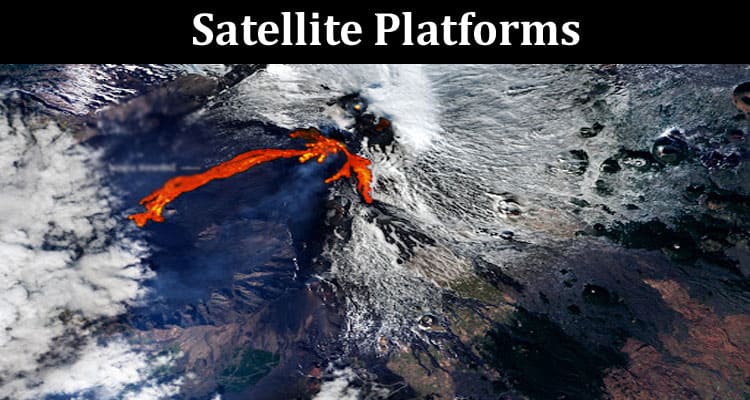
A satellite platform system employs different volcano monitoring techniques or methods to predict if there will be volcanic activity in an area. These methods include detecting tremors that precede eruptions and taking precise measurements of how the ground has deformed. Some other methods include measuring any changes in magnetic fields, gravity, volcanic gas emissions, etc. Using these methods, scientists have managed to make successful and accurate predictions about volcanoes. Forecasts based on methods of monitoring volcanoes are very reliable, but this doesn’t mean they provide the most accurate predictions. Monitoring volcanic activity for future forecasts often uses such methods as integrating geologic history, monitoring in real-time, and understanding what the internal plumbing of a volcano looks like. And even when all these methods are used, the most reliable forecasts are possible only a couple or more days before the eruption. Monitoring volcanic eruptions is important because these events are broadly destructive.
Volcano monitoring systems
Monitoring volcanoes is possible with different volcano monitoring tools, and platforms, and by analysing the volcano monitoring map of a region. There are many ways of monitoring volcanoes, but the systems used matter the most when it comes to making accurate predictions. For example, most systems use satellites or satellite platforms with radar waves that analyse a specific ground point. And when it passes that point the next time, platforms repeat a signal. If two waves are not in phase, it means the ground shifted. This system is based on Interferometric Synthetic Aperture Radar (InSAR). InSAR provides a clear picture of how the ground has deformed over a broad surface, and no instruments must be installed at the ground level. There’s also the National Volcano Warning System (NVEWS) that helps monitor very dangerous volcanoes. The European Space Agency (ESA) also launched Sentinel 1A and Sentinel-1B satellite platforms that monitor our planet’s surface. Sentinel platforms provide high-time resolution results and are timelier than InSAR.
How are satellites used to study earthquakes?
So, how do monitor an earthquake, or how do scientists do it? Today’s earthquake monitoring and warning systems use advanced satellite remote sensing platforms. Platforms for monitoring earthquakes were first introduced around the ’70s when satellite images were used for mapping active faults. Seismologists and scientists investigate the air alignment of photo geological interpretation on our planet’s surface before earthquakes and after. Geophysical methods enhance seismological satellite platform data. And then, there are electromagnetic methods that seismologists have been using for years. Thus, monitoring of earthquakes would not be possible without using advanced satellite platforms that employ remote sensing and imaging technology. There are different types of satellite platforms equipped with remote sensors and advanced cameras, so we can rest assured that our planetary studies of earthquakes will be even more accurate soon.
Can satellites detect earthquakes?
Even if we use the most advanced platforms for monitoring earthquakes, this doesn’t mean that satellites can yet help determine when there will be an earthquake. A satellite platform with GPS satellites can only alert us faster when an earthquake is going to strike. Such earthquakes monitoring satellite method is faster than using seismic sensors. Thus, people can receive alerts about an earthquake more rapidly, so they can find a safe place to protect their lives.
Satellite platforms also quantify the geophysical phenomena at the ground and indicate how our planet’s surface is changing with a mass movement or an earthquake. According to NASA, satellites can also detect some physical effects of an earthquake on Earth. Images from a satellite platform can show where there was displaced ground and what permanent changes happened at the surface. Scientists claim that satellite remote sensing platforms are becoming gradually more important when assisting with earthquake prediction. Some satellite platforms can also detect a magnetic field and a subtle infrared fluorescent glow one or two weeks before a big earthquake.
Seismology would not be a complete science without data gathered by satellite platforms with remote sensing and imaging capabilities. Earthquake and volcanic activity research methods today are complex and varied, so scientists are struggling to find out more about when the next volcano will erupt or if an earthquake will cause any serious damage to an area.